
Sources for Montgomery Neighbors
Public block research works best as a map-and-record trail. Begin with the target parcel and use the same geographic rule for every nearby lot. KaneGIS4 can find parcels and create a distance buffer. Kendall's fabric service exposes parcels, lots, subdivisions, condominiums, rights-of-way, and incorporated areas. The property roll then identifies the owner or most-recent owner attribute. That still does not prove who lives at the door.
| Source | What It Shows About a Block | Access |
|---|---|---|
| KaneGIS4 buffer | Nearby PINs and parcel mailing addresses within a defined distance | Free map; each PIN checked in DevNet |
| Kendall GIS fabric | Parcels, lots, subdivisions, condo and boundary layers | Public REST service and map |
| County property roll | Owner attribute, site address, mailing address, tax context | Kane or Kendall DevNet |
| Village records | Dated permit, ordinance, plan, or police-record activity | Online logs, counter, or FOIA |
| Neighborhood Watch | Named subdivision geography and public contact route | Village page; no member directory |
A useful block sheet records source date, PIN, site address, municipality, parcel type, and official map link. Add an owner name only when the question calls for it, and label it as a parcel record. A mailing address can sit outside Montgomery. A trust, estate, company, or association can also hold title.
Define Montgomery Neighbors' Block
“Neighbor” has no fixed public-record meaning. An adjoining parcel differs from a parcel within 300 feet. A street segment differs from a subdivision, and a ZIP code is far broader than a block. Write the rule before collecting records. Include a date because parcel boundaries and owner fields can change.
Corner lots need special care. A parcel across a road may lie in another municipality or county even when its mailing city says Montgomery. Check right-of-way, incorporated-area, lot, and subdivision layers before calling parcels adjacent. For a whole named road, use the Montgomery street directory rather than stretching a small-radius method.
Note: A clear distance, street segment, or adjacency rule makes every Montgomery block result reproducible.
Map Montgomery Neighbors' Parcels
Start from the legal or situs address, meaning the address of the land itself. Use the county map to find its PIN. The PIN is the parcel identification number that connects map, tax, assessment, and recorder records.
- Search the target address in KaneGIS4 or Kendall GIS. Save the PIN, municipality, parcel type, and source date.
- Define the radius or street segment. Export only the parcel, PIN, and site-address fields needed for comparison.
- Open each surrounding PIN in the county property system. Compare the site address with the owner mailing address.
- Add a permit, recorded document, or subdivision layer only when it answers a clear block question.
- Label every public name by its actual role and date, never as an assumed occupant.
On the Kane side, search by address or PIN, open the gold PINInfo panel, enter feet in “Buffer Dist.,” and select “Mail.” The output contains nearby parcel mailing addresses. Take each PIN into DevNet for its owner attribute. On the Kendall side, use a spatial query or click each adjacent parcel. Broad service requests may require a smaller geometry or pagination because the service caps a response at 2,000 features.
The Kendall GIS parcel and subdivision service shows the layer structure used for Montgomery neighbors.
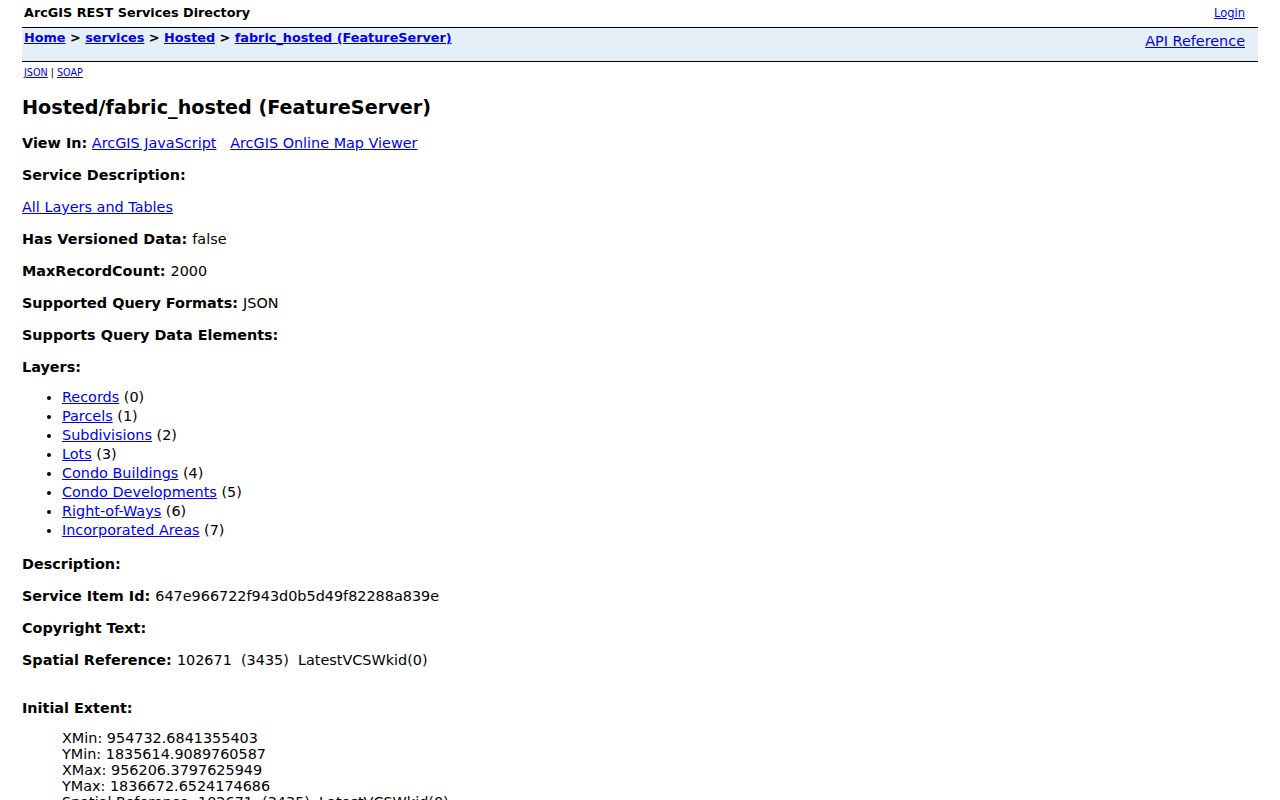
Separate parcel, subdivision, lot, and condominium layers keep a block search from treating every street number as one household.
Read Montgomery Neighbor Address Fields
Kendall's parcel layer separates the site address from the owner mailing address. It also exposes parcel type, municipality, township, brief legal description, acreage, zoning, tax class, assessment values, document references, and effective dates. These are land-record fields. The “owner” entry can be a trust, estate, business, multiple owners, or an association.
- Site address
- The address assigned to the parcel or improvement.
- Mailing address
- Where the tax notice or owner correspondence is sent.
- Adjacent parcel
- A separately identified parcel sharing a boundary with the target.
- Right-of-way
- Land reserved for a road or public travel that may separate two lots.
- Subdivision
- A recorded division of land into named lots and blocks.
Site and mailing addresses may match, but that does not establish every household member. If they differ, the owner may simply receive mail elsewhere. Preserve the distinction throughout the neighbor lookup.
Montgomery Neighbor Condo Layers
One Montgomery street number can contain many condominium units. Kendall's fabric has separate parcel-type values and layers for condo buildings, developments, and units. Search the building and unit layers separately. A parcel record may name an association or a unit owner, while the main street address represents the entire building.
Kane parcels also need a PIN check before one street number is treated as one lot. If the purpose is to understand development, Village permits, plans, and ordinances may say more than an owner field. Record the permit applicant, contractor, owner, or association only in the role printed on the file.
Find Montgomery Neighbor Block Activity
Village records add a dated activity layer to the parcel map. Building permits, monthly permit logs, ordinances, resolutions, sign files, and public-works records can connect an address to a project. A permit applicant or contractor is associated with that filing, not automatically with the household. Search by address and date when the public log permits it.
If the needed administrative record is not online, use the Village FOIA instructions. A narrow request should name the department, address or PIN, record type, and date range. The general form includes requester contact fields, a records description, and a department choice. Police has a separate form for its records.
The captured Village general FOIA form shows how to route a defined Montgomery block request.
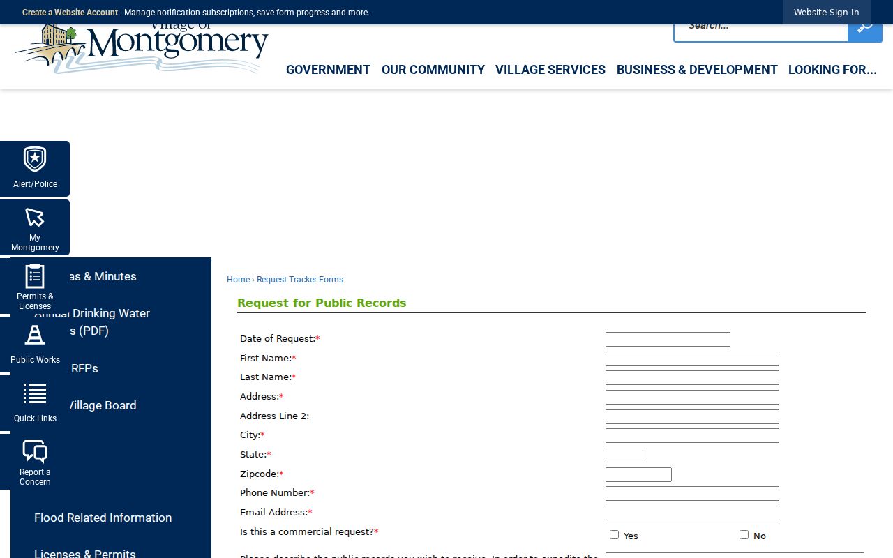
The department and description fields reward a focused request for one address, permit type, and time span.
Montgomery Neighbors Watch Areas
The Village Neighborhood Watch material supplies useful local geography, not a roster of neighbors. Named groups include Balmorea, Blackberry Crossing West, Fairfield Way/Foxmoor, Huntington Chase, Lakewood Creek West, Lakewood Creek, and Montgomery Crossings. Use those names to align subdivision, parcel, permit, and community records.
West-side groups
Blackberry Crossing West and Lakewood Creek West give subdivision labels for map and permit searches.
Named developments
Balmorea, Huntington Chase, Lakewood Creek, and Montgomery Crossings can narrow the local area.
Combined area
Fairfield Way/Foxmoor appears as a linked watch-area name rather than a public member list.
No official member directory was found. Contact routes should be used for public watch information, meeting details, or area boundaries, never to request private household contacts.
Voter Limits for Montgomery Neighbors
Kane's voter lookup uses last name, house number, and street name to return registration status, precinct, polling place, districts, and a sample ballot. Kendall links its own voter portal plus precinct lists and maps. These tools support an individual voter and election geography. They are not a lawful shortcut to a block roster.
Illinois Election Code restricts voter-list access and redacts phone numbers, dates of birth, street numbers, identifiable email, Social Security numbers, and other sensitive fields in specified statewide data. Use precinct maps to understand district boundaries. Do not assemble protected or restricted fields into a neighbor directory.
Note: A precinct describes election geography, not every person living on a Montgomery block.
Official Montgomery Records Compare Better
Commercial neighbor tools often blend property, voter, phone, court, and other data without a clear source date. Official records are narrower, but they identify the custodian, role, geographic unit, and time frame. That makes errors easier to find and correct.
| Method | Strength | Main limit |
|---|---|---|
| County GIS and assessor | PIN, parcel shape, site and owner fields | Owner is not proof of occupant |
| Village permit or ordinance | Dated activity tied to an address | Named contact has a filing role |
| Commercial compiled tool | May collect many categories | Sources, dates, and relationships may be unclear |
Use the original county, Village, library, or archive source. If a public record is wrong, ask its custodian about correction and keep supporting documents.
Protect Montgomery Neighbors' Privacy
Public parcel records do not reveal a complete household. Renters, relatives, visitors, and many occupants may not appear, while utility, delivery, driver, protected voter, restricted vital, juvenile, sealed, and adoption data must not be assembled into a block list. The Illinois Address Confidentiality Program provides eligible survivors with a substitute address and mail forwarding. Never try to reverse one.
Lawful use. Research Montgomery neighbors for civic curiosity, a defined property question, reconnection, or personal safety awareness. Never watch, harass, threaten, or intimidate anyone.
Keep names out of the first map unless a public role is directly relevant. Store the source date and relationship label with every later name. For historical neighbors, use date-specific plats, newspapers, cemetery records, and confirmed directory pages. A modern parcel map cannot be projected backward as a past household list.
Historical block work also needs the county that governed the place at the time. Kendall County was formed in 1841, and Montgomery's early settlement predates today's village line. Search Kane and Kendall archival series when an old plat or event crosses that change. The Illinois Regional Archives Depository network can identify land, tax, poll, court, and township material held for each county. Oswego Public Library staff can help locate newspaper microfilm and family-history context after the parcel and date are known. Keep each historical source tied to its own year instead of blending it with a current map.